按地理空间搜索
Overview
在本指南中,您可以学习;了解如何使用Kotlin驾驶员查询地理空间数据。您还可以学习;了解MongoDB支持的不同地理空间数据格式。
地理空间数据是表示地球表面地理位置的数据。 地理空间数据的示例包括:
电影院位置
国家/地区边界
自行车骑行路线
纽约市的狗狗运动区
地球坐标
要在 MongoDB 中存储和查询地理空间数据,请使用GeoJSON 。 GeoJSON 是由互联网工程任务组 (IETF) 创建的一种数据格式。
以下是 GeoJSON 中 MongoDB 总部的位置:
"location" : { "type": "point", "coordinates": [-73.986805, 40.7620853] }
有关GeoJSON的明确信息,请参阅 官方 IETF 规范。
GeoJSON 位置
位置表示地球上的单个地点,并以包含两个或三个数值的大量形式给出:
第一个位置的经度(必需)
第二个位置的纬度(必需)
第三个位置的海拔高度(选填)
重要
经度然后纬度
GeoJSON 将坐标排序为经度在前,纬度在后。 这可能令人惊讶,因为地理坐标系惯例通常首先列出纬度,然后列出经度。 请务必检查您正在使用的其他工具所使用的格式。 OpenStreetMap 和 Google Maps 等流行工具以纬度在前、经度在后的方式列出坐标。
GeoJSON 类型
GeoJSON 对象的类型决定了其几何形状。 几何形状由多个位置组成。
下面是一些常见的 GeoJSON 类型以及如何使用位置指定这些类型:
Point:单个位置。这可以表示雕塑的位置。LineString:两个或多个位置的数组,从而形成一系列线段。这可能代表中国长城的路线。Polygon:位置数组,其中第一个和最后一个位置相同,并包含一些空格。这可能代表梵蒂冈城内的土地。
要学习;了解有关可在MongoDB中使用的形状的更多信息,请参阅服务器手册中的GeoJSON 。
Index
要查询以GeoJSON格式存储的数据,请将包含GeoJSON数据的字段添加到 2dsphere索引中。以下代码片段使用 Indexes 构建器在 location.geo字段上创建 2dsphere索引:
collection.createIndex((Indexes.geo2dsphere("location.geo")))
要学习;了解有关 Indexes 构建器的详情,请参阅 索引构建器指南。
2D 平面上的坐标
您可以使用二维欧几里得平面上的 x 和 y 坐标来存储地理空间数据。我们将二维平面上的坐标称为传统坐标对。
legacy coordinate pairs 具有以下结构:
{ "location" : [ x, y ] }
该字段值包含一个由两个值组成的大量,其中第一个值表示 x 轴值,第二个值表示 y 轴值。
Index
要查询存储为传统坐标对的数据,必须将包含传统坐标对的字段添加到 2d索引中。以下代码片段使用 Indexes 构建器在 coordinates字段上创建 2d索引:
collection.createIndex((Indexes.geo2d("coordinates")))
要学习;了解有关 Indexes 构建器的详情,请参阅 索引构建器指南。
有关传统坐标对对的更多信息,请参阅服务器手册中地理空间查询指南的传统坐标对部分。
提示
支持的操作符
球面 (2dsphere) 和平面 (2d) 索引支持部分(但不是全部)相同的查询运算符。要查看操作符及其索引兼容性的完整列表,请参阅服务器手册中地理空间查询指南的地理空间查询操作符部分。
地理空间查询
地理空间查询由查询操作符和作为查询参数的 GeoJSON 形状组成。
查询运算符
要查询地理空间数据,请使用以下查询运算符之一:
$near$geoWithin$nearSphere$geoIntersects需要 2dsphere 索引
您可以使用Filters构建器类的near() 、 geoWithin() 、 nearSphere()和geoIntersects()实用程序方法在 MongoDB Kotlin 驱动程序中指定这些查询操作符。
要学习;了解有关地理空间查询运算符的更多信息,请参阅服务器手册中地理空间查询指南的地理空间查询运算符部分。
要学习;了解有关 Filters 构建器的详情,请参阅 过滤器构建器 指南。
查询参数
要指定在地理空间查询中使用的形状,请使用Kotlin驾驶员中的 Position、Point、LineString 和 Polygon 类。
要学习;了解有关GeoJSON形状类的更多信息,请参阅GeoJSON包 API文档。
地理空间查询示例
以下示例使用MongoDB Atlas示例数据集。您可以在Kotlin驱动程序快速入门指南中学习;了解如何设立自己的免费套餐Atlas 集群以及如何加载示例数据集。
示例使用了示例数据集 sample_mflix 数据库中的 theaters 集合。
本节中的示例需要以下导入:
import com.mongodb.client.model.geojson.Point import com.mongodb.client.model.geojson.Polygon import com.mongodb.client.model.geojson.Position import com.mongodb.client.model.Filters.near import com.mongodb.client.model.Filters.geoWithin import com.mongodb.client.model.Projections.fields import com.mongodb.client.model.Projections.include import com.mongodb.client.model.Projections.excludeId
示例文档由以下Kotlin数据类建模:
data class Theater( val theaterId: Int, val location: Location ) { data class Location( val address: Address, val geo: Point ) { data class Address( val street1: String, val street2: String? = null, val city: String, val state: String, val zipcode: String ) } }
结果文档由以下Kotlin数据类建模:
data class TheaterResults( val location: Location ) { data class Location( val address: Address ) { data class Address( val city: String ) } }
theaterscollection已包含"${Theater::location.name}.${Theater.Location::geo.name}"字段上的2dsphere索引。
按距离查询
要按从最近到最远的顺序搜索并返回文档,请使用Filters构建器类的near()静态实用程序方法。 near()方法使用$near查询运算符构造查询。
以下示例查询距离中央公园大草坪 10000 到 5000 米之间的电影院:
val database = client.getDatabase("sample_mflix") val collection = database.getCollection<TheaterResults>("theaters") val centralPark = Point(Position(-73.9667, 40.78)) val query = Filters.near( "${Theater::location.name}.${Theater.Location::geo.name}", centralPark, 10000.0, 5000.0 ) val projection = Projections.fields( Projections.include( "${Theater::location.name}.${Theater.Location::address.name}.${Theater.Location.Address::city.name}"), Projections.excludeId() ) val resultsFlow = collection.find(query).projection(projection) resultsFlow.collect { println(it) }
TheaterResults(location=Location(address=Address(city=Bronx))) TheaterResults(location=Location(address=Address(city=New York))) TheaterResults(location=Location(address=Address(city=New York))) TheaterResults(location=Location(address=Address(city=Long Island City))) TheaterResults(location=Location(address=Address(city=New York))) TheaterResults(location=Location(address=Address(city=Secaucus))) TheaterResults(location=Location(address=Address(city=Jersey City))) TheaterResults(location=Location(address=Address(city=Elmhurst))) TheaterResults(location=Location(address=Address(city=Flushing))) TheaterResults(location=Location(address=Address(city=Flushing))) TheaterResults(location=Location(address=Address(city=Flushing))) TheaterResults(location=Location(address=Address(city=Elmhurst)))
提示
MongoDB 使用与 GPS 卫星相同的参考系来计算地球上空的几何形状。
要学习;了解有关 $near操作符的更多信息,请参阅服务器手册中的 $near 参考资料。
在范围内查询
要搜索指定形状内的地理空间数据,请使用Filters构建器类的geoWithin()静态实用程序方法。 geoWithin()方法使用$geoWithin查询运算符构造查询。
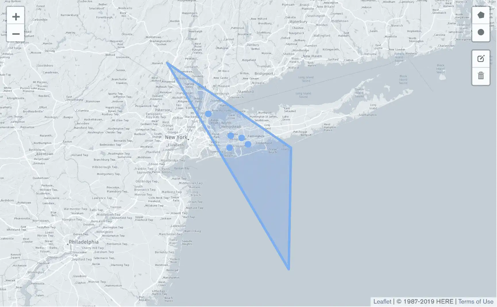
以下示例搜索长岛某个地区的电影院。
val longIslandTriangle = Polygon( listOf( Position(-72.0, 40.0), Position(-74.0, 41.0), Position(-72.0, 39.0), Position(-72.0, 40.0) ) ) val projection = Projections.fields( Projections.include( "${Theater::location.name}.${Theater.Location::address.name}.${Theater.Location.Address::city.name}"), Projections.excludeId() ) val geoWithinComparison = Filters.geoWithin( "${Theater::location.name}.${Theater.Location::geo.name}", longIslandTriangle ) val resultsFlow = collection.find<TheaterResults>(geoWithinComparison) .projection(projection) resultsFlow.collect { println(it) }
TheaterResults(location=Location(address=Address(city=Baldwin)))) TheaterResults(location=Location(address=Address(city=Levittown))) TheaterResults(location=Location(address=Address(city=Westbury))) TheaterResults(location=Location(address=Address(city=Mount Vernon))) TheaterResults(location=Location(address=Address(city=Massapequa)))
下图显示了由longIslandTriangle变量定义的多边形以及表示查询返回的电影院位置的点。

要学习;了解有关 $geoWithin操作符的更多信息,请参阅服务器手册中的 $geoWithin 参考资料。